Assignment:
Geology
Basic mapping skills are essential to the petroleum geologist. One of the more generally used map Mapping Exercise
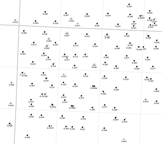
Basic mapping skills are essential to the petroleum geologist. One of the more generally used map types uses elevation data to construct a 3-D representation of a surface on a 2-D sheet of paper or computer monitor. Before the widespread use of computers, maps were hand drawn using a small set of rules that together with the geologists experience provided a map that could be used for exploration and production. Elevation maps of geological horizons are known as structure contour maps and are very useful in demonstrating the existence of structural features, such as domes, that could contain petroleum filled reservoirs. The attached base map contains wells from the Charlson Field in McKenzie County North Dakota that have the elevation of the top of the Kibbey Limestone posted. Your task is to contour these data using a contour interval of 25'. Because appearance counts, lightly sketch in your initial contours so they can be easily modified without smudges, scribbles or other flaws that would suggest a less than professional effort. On your final map you can properly draw or darken your contour lines. Remember to label your contours. Keep a copy of this map so that when we computer map these same data you can get a sense of the pros and cons of automated map making.
Exercise 1 - Contouring Data.
The base map shown below shows the location of well heads and the elevation of the Kibbey Limestone.


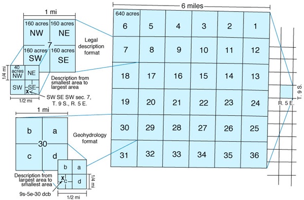
The illustration above shows the standard numbering system that is applied to every standard Township and Range. You should be able to figure out from the scale bar that the heavy dark gray lines represent Township and Range lines and that the light gray lines are section lines.
1) Contour the elevation data and determine what type of structure is present.
2) Based on your analysis of the structure contour map, propose a reason why there is gas production in Section 6.
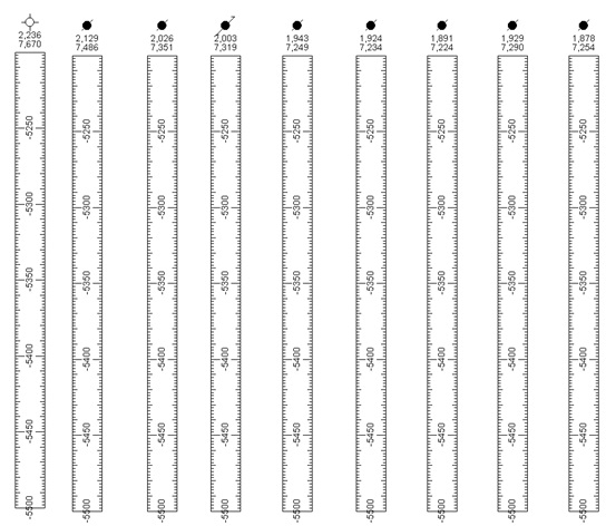
3) Construct an elevation profile of the Kibbey Limestone on the diagram below. Each column represents a vertical well with the elevation of the K.B. (top) and depth to the top of the Kibbey Limestone (below) plotted below the well symbol. Calculate the elevation of the Kibbey Limestone and plot the result on the column below the posted data. Draw a profile that represents the elevation/structure of the Kibbey Limestone that these wells revealed.
a. Does the structure you see confirm the structure contour map?
b. Find the wells on the base map that were used to make the cross-section. Draw a line through these wells on the basemap to show the location of the cross-section on the base map. Label the cross-section with A on one side and A' on the other. Label the ends of the line on the base map so that it corresponds with the labels on the cross-section.
